


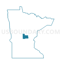
Lastrup Voting District, Morrison County, Minnesota
About
Outline

Summary
| Unique Area Identifier | 603212 |
| Name | Lastrup Voting District |
| County | Morrison County |
| State | Minnesota |
| Area (square miles) | 0.45 |
| Land Area (square miles) | 0.44 |
| Water Area (square miles) | 0.01 |
| % of Land Area | 97.23 |
| % of Water Area | 2.77 |
| Latitude of the Internal Point | 46.03984420 |
| Longtitude of the Internal Point | -94.06176950 |
Maps


Graphs
Select a template below for downloading or customizing gragh for Lastrup Voting District, Morrison County, Minnesota


Neighbors
Neighoring Voting District (by Name) Neighboring Voting District on the Map
- Buh Township Voting District, Morrison County, MN
- Granite Township Voting District, Morrison County, MN
Top 10 Neighboring County Subdivision (by Population) Neighboring County Subdivision on the Map
- Buh township, Morrison County, MN (520)
- Granite township, Morrison County, MN (481)
- Lastrup city, Morrison County, MN (104)